
GRAND RAPIDS, Mich — It's time to beat the heat because this week features multiple days of hot temperatures and high humidity levels. All the heat and humidity could also fuel our storm potential mid-week.
Let's break it down.
TEMPERATURES
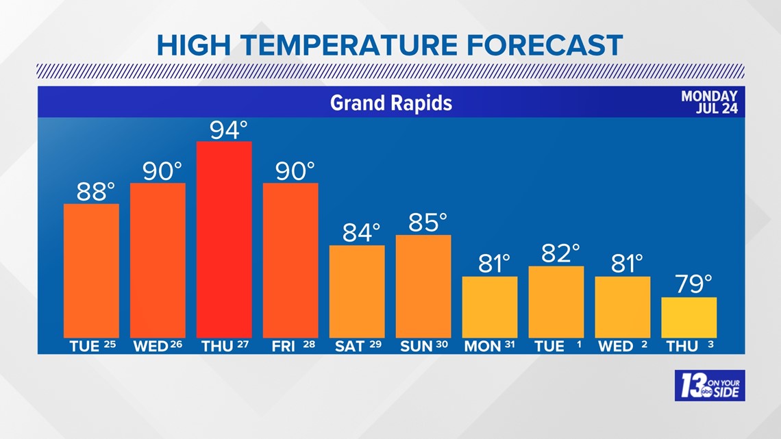
Today will be fairly typical for a late July day, with highs in the mid-80s, under partly cloudy to mostly sunny conditions. Tomorrow gets a little hotter with a forecast high of 88°. By midweek an upper-level ridge will build into place and hot surface temperatures will be the result. We make it into the low 90s on Wednesday, mid-90s on Thursday, and low 90s again on Friday. The good news is that by the weekend we look to return to more seasonal conditions for the remainder of the 10-day forecast.

HUMIDITY
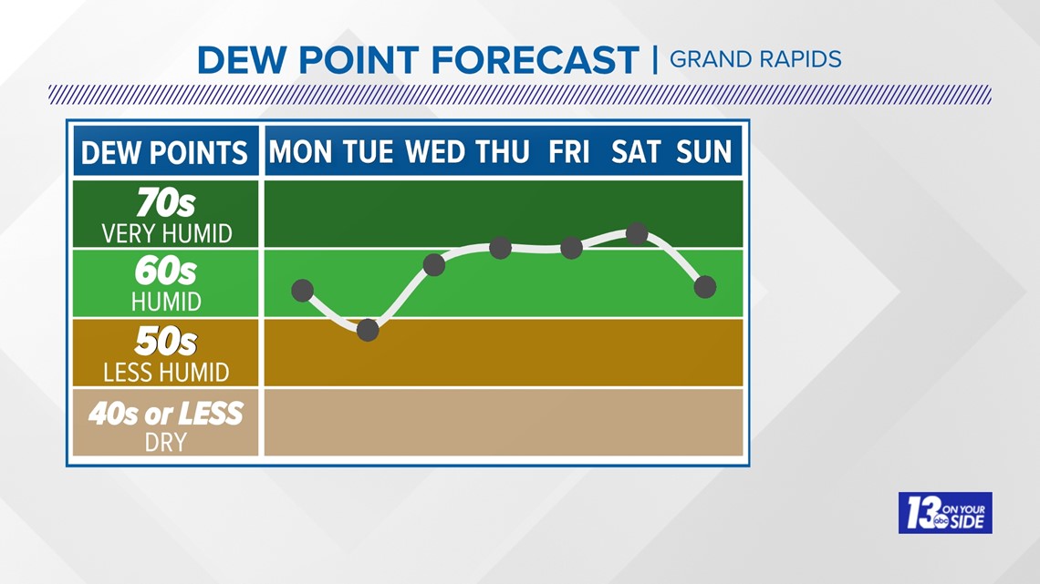
We all know the saying... "It's not the heat, it's the humidity." This time around it'll be both. Conditions will be slightly humid today and a little more comfortable tomorrow. After that, they climb at or near the very humid category from Wednesday through Saturday. This is going to result in a thick, moisture-rich airmass, making it feel even warmer outside.

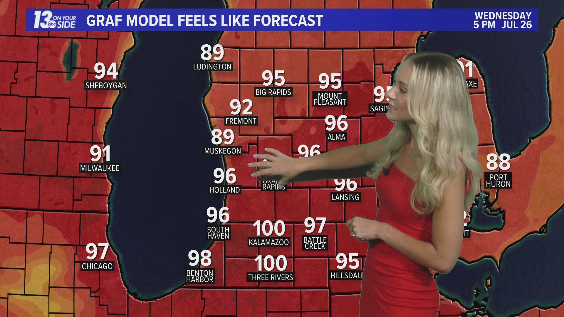
FEELS-LIKE
Because of the high moisture content in the air, the heat index—or what the temperature feels like to the human body when relative humidity is combined with the air temperature—is going to be even hotter than what your thermometer reads. This is an important consideration when planning any outdoor activities. The human body will sweat in order to cool itself down, but when relative humidity levels are too high that sweat does not evaporate as easily, slowing down the body's cooling process. This can result in heat cramps, heat exhaustion, or even heat strokes without taking proper breaks from the heat. Wednesday through Friday will bring feels-like temperatures in the upper 90s to low triple digits.
STORMS
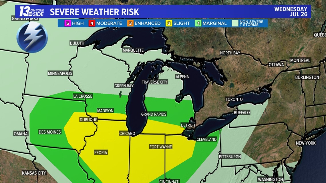
In addition to the heat and humidity, we do have the potential for strong to severe storms Wednesday afternoon. The Storm Prediction Center has placed all of West Michigan under a level 1/5 threat and along and south of I-94 under a level 2/5 threat.
Please continue to check in for more details on this.

6-10 Day Outlook
Sat. Jul. 29 through Wed. Aug. 2 calls for above average temperatures and above average precipitation. Average highs are around 82-83° with an average precipitation of 0.62".
8-14 Day Outlook
Mon. Jul. 31 through Sun. Aug. 6 calls for below average temperatures and below average precipitation. Average highs are around 82-83° with an average precipitation of 0.85".
Have a 30-second video or photo to share? We'd love to share it with everyone! Share your images by texting your name and location to 616.559.1310 or email to Weather@13OnYourSide.com or post it to our 13OnYourSide Facebook Page
►Make it easy to keep up to date with more stories like this. Download the 13 ON YOUR SIDE app now.
Have a news tip? Email news@13onyourside.com, visit our Facebook page or Twitter. Subscribe to our YouTube channel.