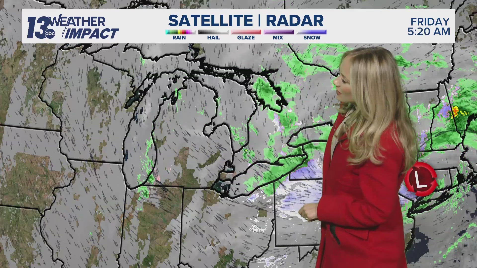
GRAND RAPIDS, Mich. — The remnants of what was once Hurricane Beryl barreled through Lower Michigan late Tuesday through Wednesday evening leaving behind soaking rainfall up to 6'' leading to minor flooding across West Michigan.
How much rain fell?
The outer rain bands from Beryl reached the I-94 corridor during the afternoon on July 9, eventually reaching the I-96 corridor around 11 pm, then continued north overnight. As expected the heaviest rainfall occurred over the SE portions of Lower Michigan with up to 6'' in some locations.

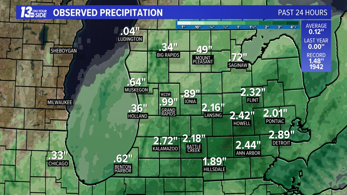
Many locations received over 2'' with lower amounts over the NW counties.

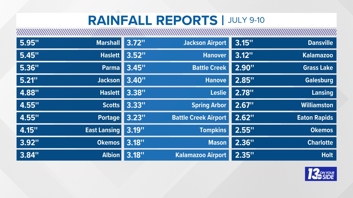
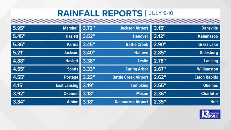
Here are the rainfall reports for all locations:
- Marshall 5.95''
- Haslett 5.45''
- Parma 5.36''
- Jackson 5.21''
- Haslett 4.88''
- Scotts 4.55''
- Portage 4.55''
- East Lansing 4.15''
- Okemos 3.92''
- Albion 3.84''
- Jackson Airport 3.72''
- Hanover 3.52''
- Battle Creek 3.45''
- Hanover 3.40''
- Leslie 3.38''
- Spring Arbor 3.33''
- Battle Creek Airport 3.23''
- Tompkins 3.19''
- Mason 3.18''
- Kalamazoo Airport 3.18''
- Dansville 3.15''
- Kalamazoo 3.12''
- Grass Lake 2.90''
- Galesburg 2.85''
- Lansing 2.78''
- Williamston 2.67''
- Eaton Rapids 2.62''
- Okemos 2.55''
- Charlotte 2.36''
- Holt 2.35''
- Eaton Rapids 6.6 N 2.31''
- Lansing 1.3 WNW 2.26''
- Okemos 2.21''
- Williamston 4.0 ESE 2.19''
- Lansing 3.3 WNW 2.18''
- Edgemont Park 0.7 NNE2.18''
- Kalamazoo 1.6 WSW 2.15''
- Lawton 2.10''
- Lansing 4.7 NW 2.09''
- Laingsburg 5.0 SW 2.07''
- Laingsburg 2.1 NW 2.04''
- Lansing 2.02''
- Laingsburg 2.1 NNW 2.02''
- Battle Creek 11.7 NNW1.95''
- 2 NNW Caledonia 1.91''
- Freeport 1.6 S 1.71''
- 1.3 NW Grand Ledge 1.70''
- Allegan 1.68''
- Plainwell 1.68''
- DeWitt 1.0 NNW 1.63''
- Plainwell 5.4 E 1.62''
- 4 N Vermontville 1.58''
- Gerald R Ford Intl 1.58''
- Hopkins 1.55''
- Paw Paw 2.0 NE 1.54''
- Caledonia 1.52''
- Marshall Brooks Field1.49''
- 4.2 NW Smyrna 1.47''
- Caledonia 4.4 WNW 1.47''
- Byron Center 1.42''
- Grand Junction 1.41''
- Decatur 7.0 WNW 1.35''
Urban and rural flooding
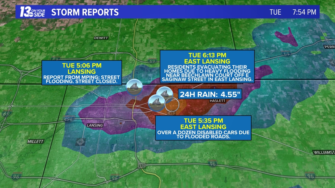
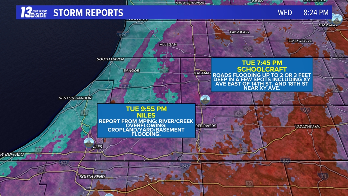
Some areas south and east of Grand Rapids experienced urban flooding, especially in Ingham and Kalamazoo counties.


River flooding
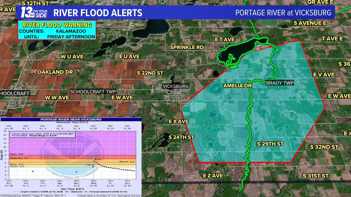
River Flood Warnings were issued for the Portage River near Vicksburg as rapid rises in river levels led to some flooding.

Share your weather reports, photos and videos
As always follow West Michigan's most experienced team of meteorologists and participate in citizen science with your videos, photos and personal weather observations.


Chief Meteorologist George Lessens
George is a graduate of Penn State University working for 13 On Your Side for nearly 44 years. He is a Certified Broadcast Meteorologist (CBM), a thirteen-time MAB® Weathercast Award Winner, four-time EMMY® Award Winner, NATAS® Silver Circle Award Winner, Weather-Ready Nation® Ambassador, and the AMS Charles Mitchell Award for lifetime service.
Contact me at: GeorgeLessens@13OnYourSide.com
Follow me on Threads and X @glessens and Facebook GeorgeLessensWZZM
Have a 30-second video or photo to share? We'd love to share it with everyone! Share your images by texting your name and location to 616.559.1310 or email to Weather@13OnYourSide.com or post it to our 13OnYourSide Facebook Page


