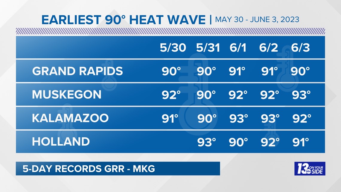
GRAND RAPIDS, Mich. — The recent heat wave set records for West Michigan, including the highest number of consecutive 90° days so early in the year.
Grand Rapids
High temperatures reached 90°+ every day between May 30 and June 3; however, none were hot enough to set daily records. Although, the morning readings on 67° on June 2 and 64° on June 3 set records for the warmest low temperatures.
The five days from May 30 to June 3, 2023 was the longest in history; the previous record was fours days from May 30 to June 2, 1919.
Muskegon
High temperatures also reached 90°+ every day between May 30 and June 3. Each day, new daily high temperatures were set.
- May 30 - 92°; previous record 90° in 2018.
- May 31 - 90°; previous record 88° in 2016.
- June 1 - 92°; previous record 88° in 1988 and 2014.
- June 2 - 92°; previous record 87° in 1963.
- June 3 - 93°; previous record 90° in 1919.
The five days from May 30 to June 3, 2023 was also the longest in history; the previous record was three days from May 28 to May 30, 1962.


Kalamazoo
High temperatures also reached 90°+ every day between May 30 and June 3; however, like Grand Rapids, none were hot enough to set daily records.
Even though these five consecutive days were impressive it wasn't the earliest on record.
- 5 days - May 15-19, 1962
- 5 days - May 27-31, 1987
- 5 days - May 30 - June 3, 1919
- 5 days - May 30 - June 3, 2023
Holland
High temperatures reached 90°+ for four days between May 31 and June 3 but the only record set was 93° on May 31; the previous record was 92° in 1934.
The weather pattern shifted slightly on June 4 with high temperatures dipping into the 80s, ending the unprecedent early-season heat wave.
What's Ahead
Temperatures will be more seasonable in the upper 70s to around 80° through Saturday and then cooling off into the 70s Sunday through Tuesday.


Chief Meteorologist George Lessens
George is a graduate of Penn State University working for 13 On Your Side for over 42 years. He is a Certified Broadcast Meteorologist (CBM), a thirteen-time MAB® Weathercast Award Winner, two-time EMMY® Award Winner, NATAS® Silver Circle Award Winner, and Weather-Ready Nation® Ambassador.
Contact me at: GeorgeLessens@13OnYourSide.com
Follow me on Twitter @glessens and Facebook GeorgeLessensWZZM
Have a 30-second video or photo to share? We'd love to share it with everyone! Share your images by texting your name and location to 616.559.1310 or email to Weather@13OnYourSide.com or post it to our 13OnYourSide Facebook Page
►Make it easy to keep up to date with more stories like this. Download the 13 ON YOUR SIDE app now.
Have a news tip? Email news@13onyourside.com, visit our Facebook page or Twitter. Subscribe to our YouTube channel.


