GRAND RAPIDS, Mich. — Monday began with thunderstorms and localized flooding, and going into the night hours more storms began to hit.
WHAT
Early thunderstorms/heavy rain ended, with clearing skies this morning into the midday hours. Very warm and humid conditions continued through the afternoon as temperatures soared into the 80s and dew point values climbed into the upper 60s to lower 70s (noticeably muggy).


Focus of the forecast comes towards the end of Monday as thunderstorms blossom upstream across portions of Iowa, Wisconsin, and Illinois. As the storms approached various tornado warnings and severe thunderstorm warnings were issued.
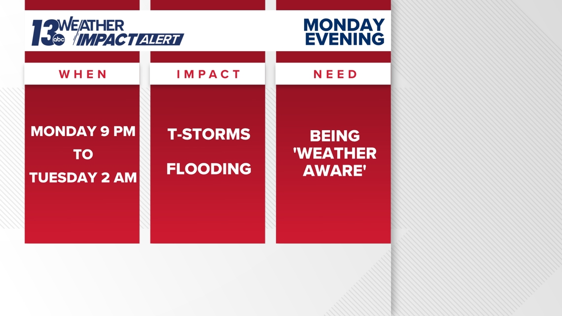
Thunderstorms will progress through West Michigan from west to east, arriving at the lakeshore around 9 p.m. and exiting the area by 2 a.m.
Kalamazoo, Van Buren, Barry and Allegan counties were placed under a tornado warning by the National Weather Service. That warning is set to expire at 2 a.m.

IMPACTS
The bulk of West Michigan ranges from an Enhanced Risk (level 3) to a Slight Risk (level 2) for severe weather Monday evening into the night hours. Damaging wind is the main risk in any strong to severe thunderstorm that organizes.

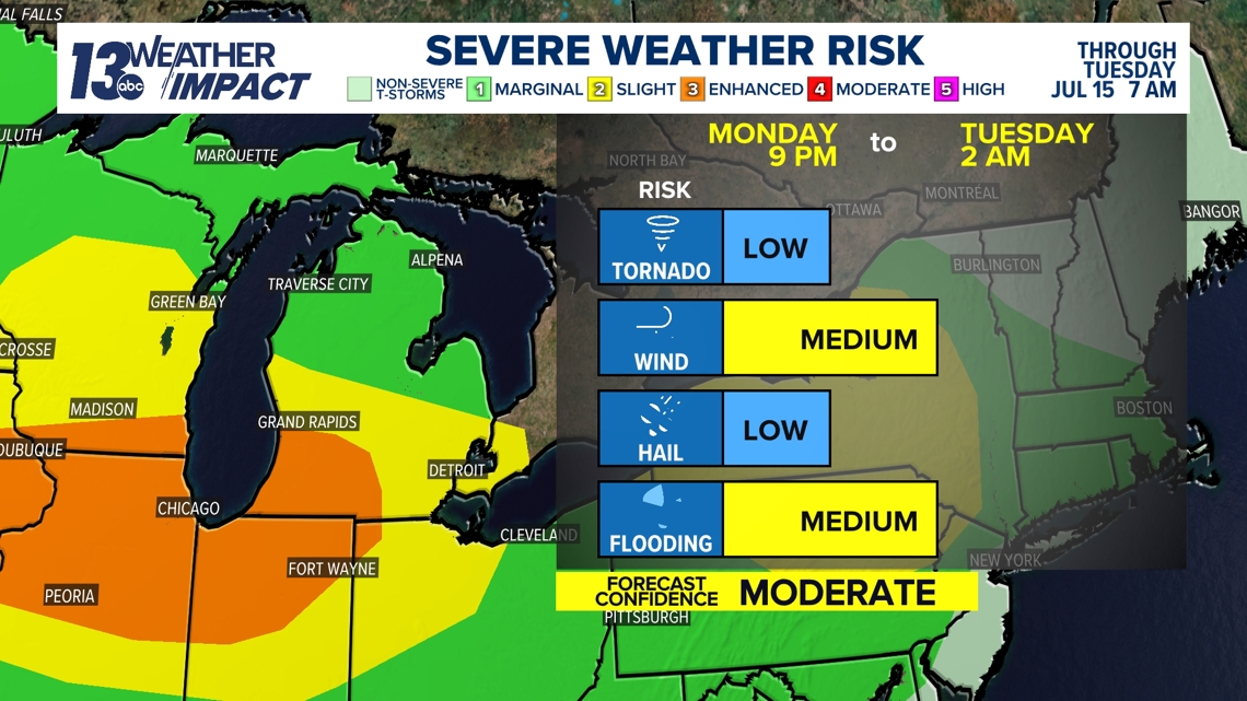
Across the 13 On Your Side viewing area, this Enhanced Risk includes the southern half of Allegan Co., the western half of Kalamazoo Co., and the entirety of Van Buren County. All severe weather modes – damaging wind, hail, and a brief tornado – are all possible in this risk category.
Another concern will be the possibility of additional flooding from heavy rain that occurs. Typical low-lying areas/flood prone spots will be most susceptible to flooding.

NEED
You should have multiple ways to stay weather aware and receive critical weather information:
1. NOAA Weather Radio
The first is NOAA Weather Radio. We often refer to them as the “smoke detector” for severe weather, because they will automatically sound an alarm in the case of a natural disaster or severe weather.
2. Local Broadcast
There is also always your local TV station. The 13 ON YOUR SIDE Weather Department streams on-air and online during an active storm.
Download the 13 ON YOUR SIDE app now. When you open the app, you can enable your location to be sent active alerts in your area.
You can see the latest severe weather alerts here.
3. Radio Station
Local radio stations should alert you if a storm is in your area. You can even set up devices like Alexa and Google Home to alert you with weather notifications.
4. Smartphone
Your smartphones also offer numerous ways to receive critical weather alerts. We have a 13 ON YOUR SIDE Weather App allowing you to track the storm and receive alerts.
Download our weather app from the App Store for Apple Devices or for your Android device here.
5. Outdoor Sirens
Outdoor sirens are also an option, as they will go off in the threat of immediate danger, but are only meant to be heard outdoors. So, if you are inside, this should not be how you receive your severe weather alerts. Outdoor sirens can also be unreliable, difficult for those hard of hearing, and go off for other reasons beyond tornadoes.
TEXT US
TEXT your weather photos to us at 616-559-1310.
Please include the following with your photo(s):
- Your storm photos
- Your first and last name
- Date and time of your photos
- Locations of your photos
- What’s in your photos?
You can upload videos to YouTube and send the links to us, send them to us over Facebook Messenger, and short videos can be sent via email to wxwatcher@13OnYourSide.com
Have a 30-second video or photo to share? We'd love to share it with everyone! Share your images by texting your name and location to 616.559.1310 or email to Weather@13OnYourSide.com or post it to our 13OnYourSide Facebook Page
►Make it easy to keep up to date with more stories like this. Download the 13 ON YOUR SIDE app now.
Have a news tip? Email news@13onyourside.com, visit our Facebook page or Twitter. Subscribe to our YouTube channel.
Watch 13 ON YOUR SIDE for free on Roku, Amazon Fire TV Stick, and on your phone.