
GRAND RAPIDS, Mich. — A thunderstorm complex developed late Monday night, June 24, 2024 over NW Wisconsin and moved through West Michigan early Tuesday morning with damaging winds up to 70+ mph in parts of West Michigan.
TIMELINE
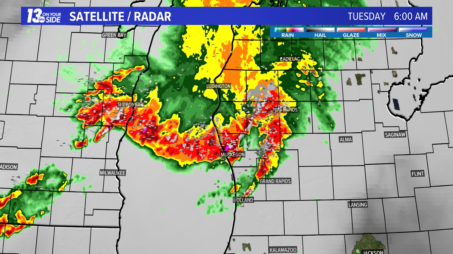
The storms arrived onshore in NW Lower Michigan near Mason and Oceana counties around 4:00 am. By 6:00 am the thunderstorm surged across Muskegon County and then accelerated into Kent and Ottawa counties by 8:00 am. The storm bowed out from there and rushed into Allegan and Barry counties next, and finally into Van Buren, Kalamazoo and Calhoun counties by 10:00 am.
IMPACTS
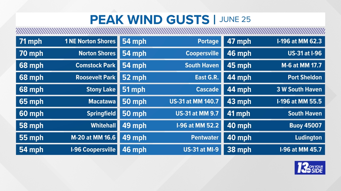
Winds gusted to 70+ mph in Norton Shores and over 50+ mph in many other locations, leading to downed trees and power lines leaving up to 150,000 energy customers without power.

RECORD-BREAKING WINDS
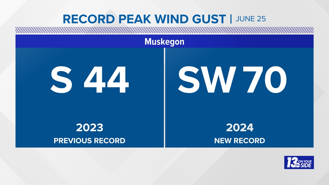
Muskegon recorded a peak wind gust of 70 mph at 6:05 am setting a daily record for June 25 and the record for June. The previous record was 44 mph set in 2023. That 70 mph wind tied for the second highest peak gust with September 6, 2020. The strongest peak wind gust on record for Muskegon was 78 mph on December 23, 2007.

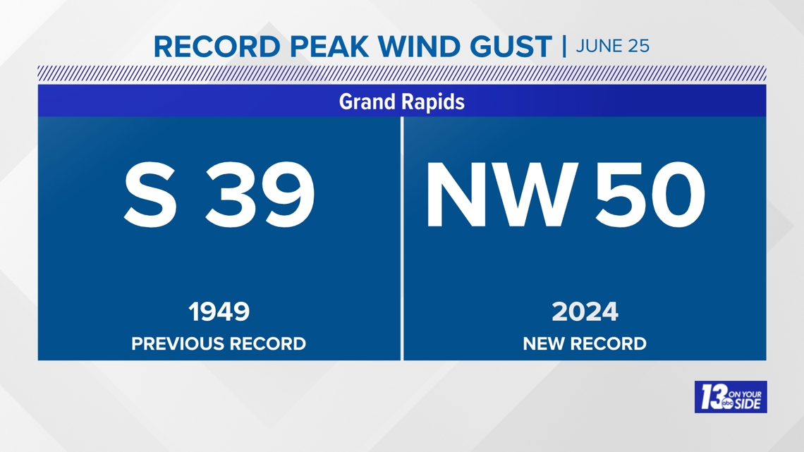
Grand Rapids also set a record with a 50 mph wind gust at 6:49 am. The previous record was 39 mph set in 1949.

RAINFALL
Wind-whipped rain soaked the area with amounts ranging from 1-2'' caused brief flooding in Van Buren county.

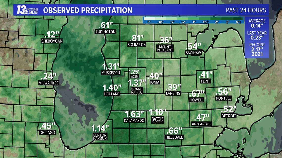
Here are some additional amounts:
- 2.48" Grand Junction
- 2.16" 1 E Bangor
- 2.12" Saugatuck 5.0 Ene
- 2.10" 1.6 Ne Hartford
- 1.97" 2 W Schoolcraft
- 1.91" Scottville 2.1 Ese
- 1.78" Otsego 0.9 Wnw
- 1.76" Zeeland
- 1.72" Jamestown
- 1.70" Byron Center
- 1.69" Kalamazoo
- 1.67" Holland
- 1.65" Hudsonville
- 1.65" Gitchel
- 1.63" Hart 3 Wsw
- 1.62" Plainwell
- 1.61" Holland
- 1.60" Fennville 0.8 W
- 1.58" Grand Haven
- 1.58" 2.3 W Fennville
- 1.53" Holland 4.2 Nw
- 1.53" Allegan
- 1.51" Baldwin
- 1.50" White Cloud 7.5 Ene
- 1.50" Allegan 0.3 Nnw
- 1.43" Lawton
- 1.42" North Muskegon 4.9 Ne
- 1.42" 3 Se Nunica
- 1.41" 1 E Grand Haven
- 1.35" Kalamazoo/Bc Intl Airport
- 1.33" Hopkins
- 1.29" Spring Lake
- 1.27" Holland 5.3 Wsw
- 1.27" Byron Center
- 1.22" Spring Lake
- 1.20" Muskegon 2.3 Ssw
- 1.20" Wayland 4.9 Nnw
- 1.19" Alto 4.5 Sw
- 1.16" Hopkins
- 1.13" Grand Haven 0.2 Sw
- 1.11" Comstock Park 1.0 Nnw
- 1.10" Holland 4.3 Nnw
- 1.10" Allegan
- 1.10" Jenison 0.8 W
- 1.09" Norton Shores
- 1.07" Hopkins
- 1.06" North Muskegon 2.4 Nw
- 1.05" Allendale
- 1.04" Battle Creek 0.6 S
- 1.02" Sparta 0.3 Ne
- 1.02" Grandville
- 1.00" 1 Wsw Kentwood
- 1.00" 3 S Lakeview
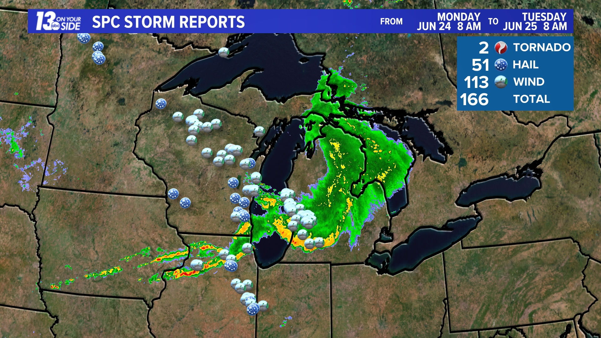
STORM REPORTS
Up to 166 reports of severe weather occurred between 8 am Monday and 8 am Tuesday, the majority from damaging winds.
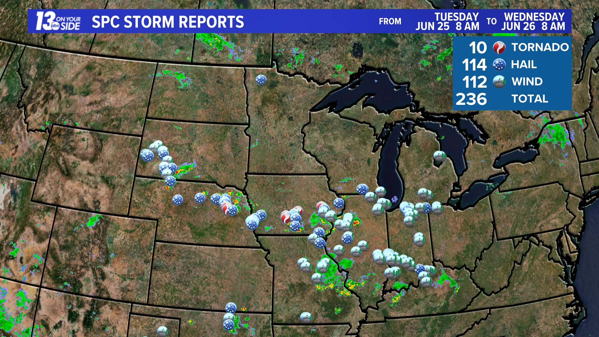
From 8 am Tuesday through 8 pm an additional 236 storm reports were noted.
SUBMIT YOUR PHOTOS AND VIDEOS
You can share your storm reports along with photos and videos by texting the word "STORM" to 616-559-1310 or scan the QR code below.


Always watch the 13 On Your Side team of experienced meteorologists for the most complete and most accurate forecasts in West Michigan.
Chief Meteorologist George Lessens
George is a graduate of Penn State University working for 13 On Your Side for nearly 44 years. He is a Certified Broadcast Meteorologist (CBM), a thirteen-time MAB® Weathercast Award Winner, four-time EMMY® Award Winner, NATAS® Silver Circle Award Winner, Weather-Ready Nation® Ambassador, and the AMS Charles Mitchell Award for lifetime service.
Contact me at: GeorgeLessens@13OnYourSide.com
Follow me on Threads and X @glessens and Facebook GeorgeLessensWZZM
Have a 30-second video or photo to share? We'd love to share it with everyone! Share your images by texting your name and location to 616.559.1310 or email to Weather@13OnYourSide.com or post it to our 13OnYourSide Facebook Page