MICHIGAN, USA — Pleasant summer-like conditions controlled the weekend forecast, but attention turns to the potential of stormier weather, including a severe risk, for the first half of this upcoming week.
MONDAY
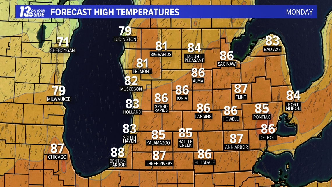
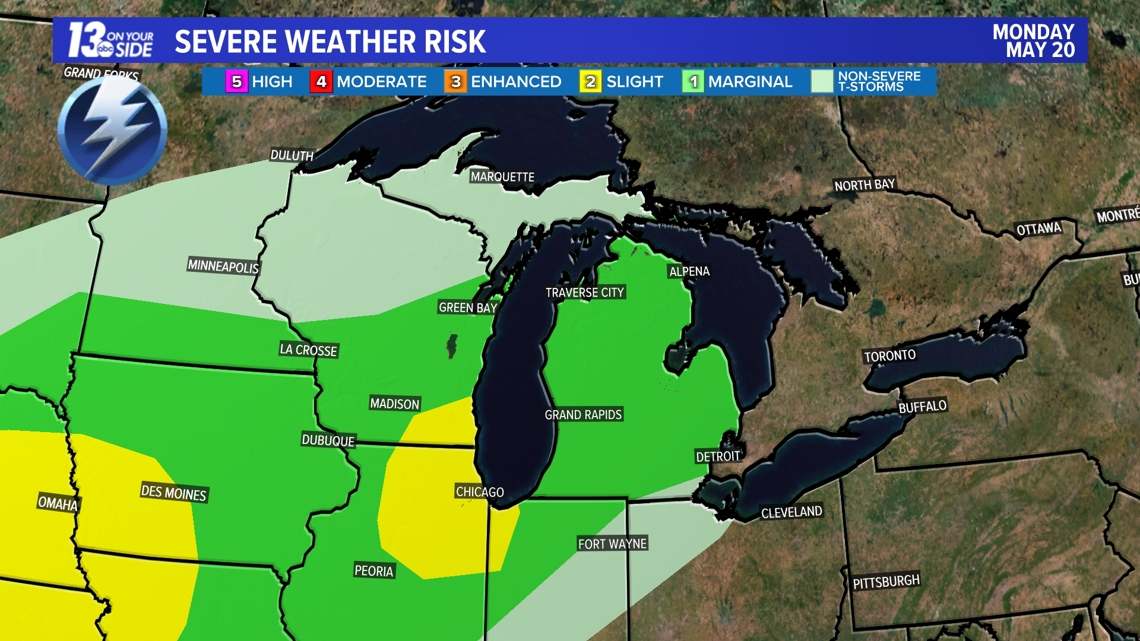
It’ll remain warm and noticeably more humid to kick off the week as temperatures soar into the 80s and dew point values climb above 60 (which is muggy for W. Michigan standards). This combination will create a slightly unstable airmass across the Great Lakes, allowing the potential for thunderstorms to develop during the afternoon and evening hours. A caveat, however, is the coverage of thunderstorms, which remains low in confidence.


As of now, the Storm Prediction Center has a Marginal Risk (level 1 out of 5) across West Michigan. The risk includes the potential of strong/damaging wind and hail.


TUESDAY
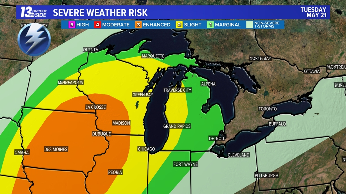
Conditions remain warm and humid into Tuesday, keeping the summer-like feel around. The difference comes in the way of an approaching cold front late in the day, which heightens the opportunity of stronger to severe thunderstorms. The detail that needs to be ironed out is the exact timing of the cold front as an earlier arrival (during the evening hours) would increase the severe risk with more instability available. In turn, a later arrival (during the nighttime hours) would lessen the severe risk with less instability available.
The Storm Prediction Center has much of West Michigan – at least towards the lakeshore – under a Slight Risk (level 2 out of 5). All modes of severe weather are possible late Tuesday.


REST OF THE WEEK
Towards the end of the week – especially Thursday and Friday – cooler and tranquil conditions return to West Michigan. Average high temperatures are in the lower 70s for the end of May, which is where we’ll settle Thursday and Friday.
Much of Memorial Day Weekend appears quiet, with only a scattered rain chance overnight Saturday into Sunday. Impactful weather looks limited, at best.
WAYS TO GET WEATHER ALERTS
You should have multiple ways to stay weather aware and receive critical weather information:
1. NOAA Weather Radio
The first is NOAA Weather Radio. We often refer to them as the “smoke detector” for severe weather, because they will automatically sound an alarm in the case of a natural disaster or severe weather.
2. Local Broadcast
There is also always your local TV station. The 13 ON YOUR SIDE Weather Department streams on-air and online during an active storm.
Download the 13 ON YOUR SIDE app now. When you open the app, you can enable your location to be sent active alerts in your area.
You can see the latest severe weather alerts here.
3. Radio Station
Local radio stations should alert you if a storm is in your area. You can even set up devices like Alexa and Google Home to alert you with weather notifications.
4. Smartphone
Your smartphones also offer numerous ways to receive critical weather alerts. We have a 13 ON YOUR SIDE Weather App that will allow you to track the storm and receive alerts.
Download our weather app from the App Store for Apple Devices or for your Android device here.
5. Nixle Alerts
- Nixle is a FREE comprehensive warning system designed for rapid dissemination of alerts and public information to a variety of public mechanisms.
- Alerts and emergency information are received via text, email, web, and social media in real time for localized emergency situations relevant to the community.
- To register for NIXLE ALERTS
- Text your Zip Code to 888777
- Sign up and create a user profile at https://local.nixle.com/register/
6. Outdoor Sirens
Outdoor sirens are also an option, as they will go off in the threat of immediate danger, but are only meant to be heard outdoors. So, if you are inside, this should not be how you receive your severe weather alerts. Outdoor sirens can also be unreliable, difficult for those hard of hearing, and go off for other reasons beyond tornadoes.
Share your weather photos and videos with us!
TEXT your weather photos to us at 616-559-1310.
Please include the following with your photo(s):
- Your storm photos
- Your first and last name
- Date and time of your photos
- Locations of your photos
- What’s in your photos?
You can upload videos to YouTube and send the links to us, send them to us over Facebook Messenger, and short videos can be sent via email to wxwatcher@13OnYourSide.com
►Make it easy to keep up to date with more stories like this. Download the 13 ON YOUR SIDE app now.
Have a news tip? Email news@13onyourside.com, visit our Facebook page or Twitter. Subscribe to our YouTube channel.
Watch 13 ON YOUR SIDE for free on Roku, Amazon Fire TV Stick, Apple TV and on your phone.


