GRAND RAPIDS, Mich — After a widespread system of snow, we are now preparing for another round of impactful lake-effect snow in parts of West Michigan.
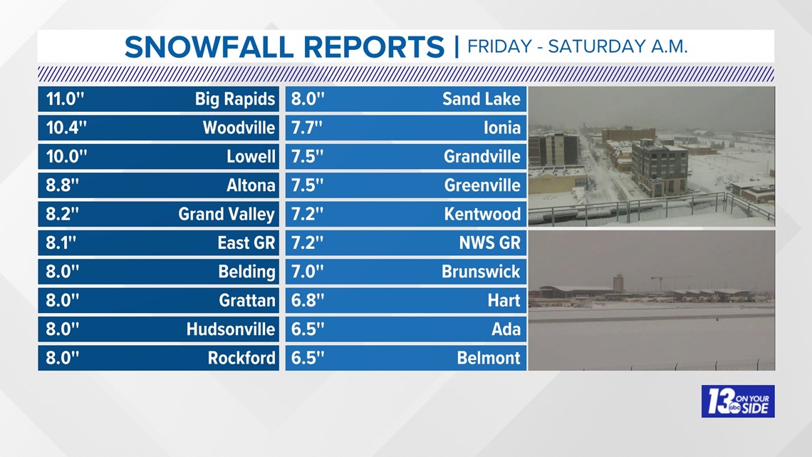
SNOW TOTALS: FRIDAY - SATURDAY A.M.
Widespread 6-8", with localized heavier amounts were reported across West Michigan from Friday's system snow. The nature of the snow was wet and heavy, causing scattered power outages across the area.
Travel was impacted greatly during the Friday evening commute before improving overnight into early Saturday.
There were isolated pockets that saw less snow, on the order of 3-6", but impacts remained for all.

WHAT: LAKE EFFECT
As Friday's low-pressure system exits, Michigan's cold Arctic air descends behind it, causing the lake effect machine to blossom.
The high-impact snow will primarily affect lakeshore counties as strong winds generate W-NW lake-effect snow bands throughout Saturday. The strong winds will allow lake effect snow to trek well inland east of US-131, but not as impactful in terms of accumulation.
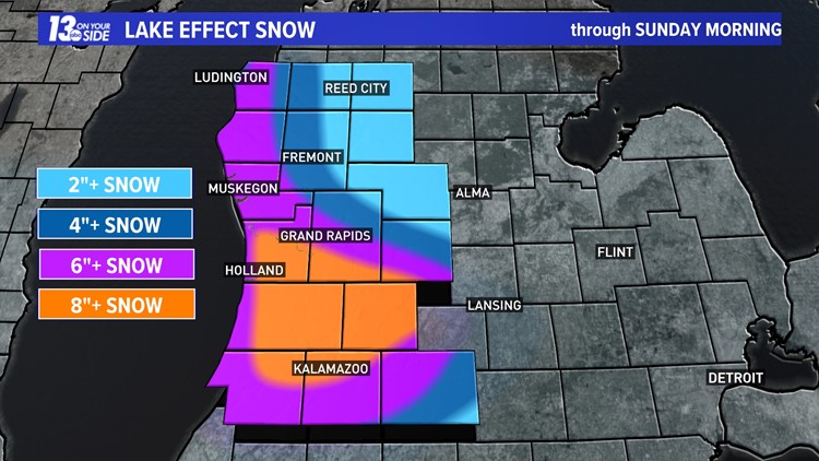
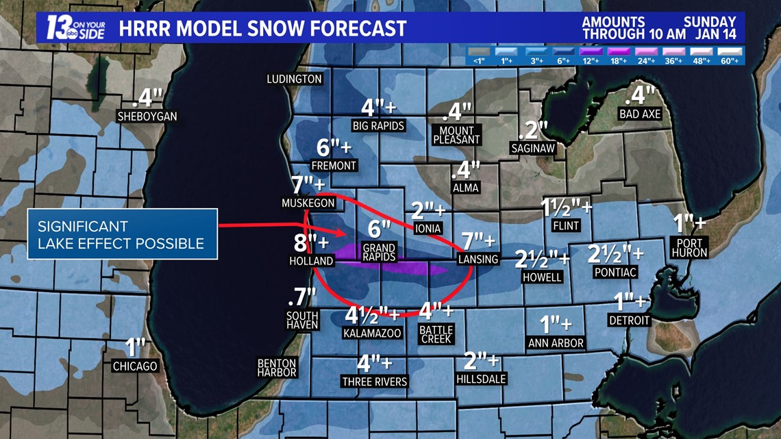
Significant lake effect snow is expected Saturday evening through Sunday morning, as a dominant band and/or plume of snow takes shape near to slightly southward of I-96. This is due to continued Arctic air spilling into the Great Lakes, along with a convergence of winds out of the west. The combination allows for increased moisture off of Lake Michigan, and in turn, causing snowfall to increase in coverage and intensity.
Coverage and intensity of lake effect snow will diminish Sunday afternoon and evening, primarily becoming confined to lakeshore communities.
The snow will no longer be heavy wet snow; instead, it will be lighter and fluffier, making it easier to blow and shovel.
TOTALS
By the end of Sunday morning, we expect 4 to 6"+ of snowfall west of US-131. Highest snowfall totals will be near and southward of I-96, with snowfall of 8"+ expected by the end of Sunday morning.
Areas of focus include Ottawa, Allegan, Barry, Kent, Van Buren, and Kalamazoo counties. This is due to the band and/or swath of significant lake effect snow that develops Saturday evening into Sunday morning. It is not out of the question localized areas near and south of I-96 contend with double digit snowfall by the end of the weekend.
This is lake-effect snow, so conditions could result in near-whiteouts for some areas, with rapid improvement within a few-mile radius. The further northwest of Kent county one travels, the lower the snowfall totals will be.


COLD AIR
Bitterly cold air is the other focus of the forecast; steadily advancing into West Michigan throughout the weekend. Temperatures will remain below freezing for upwards of a week, meaning there'll be no melting of the snow that has fallen and is expected ahead.

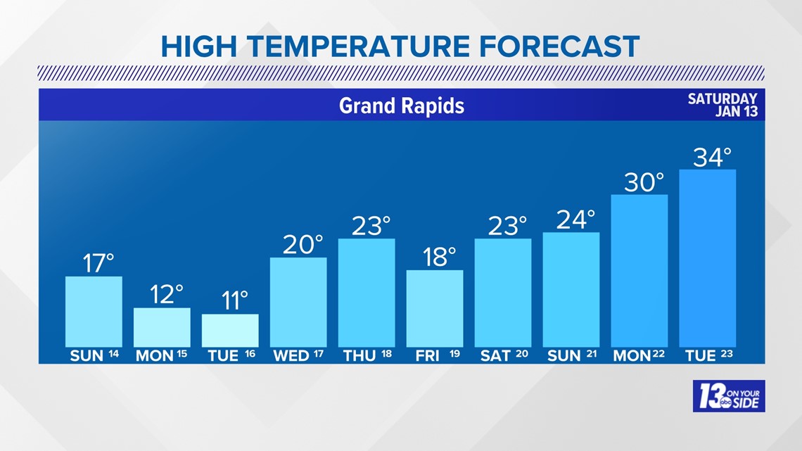
Temperatures on Sunday will only top out in the 10s, with a "feels like" temperature of 3 degrees in Grand Rapids at daybreak. Wind chill values will be sub-zero periodically the rest of Sunday, through at least Monday and Tuesday. Frostbite could potentially occur within 30 minutes of exposure to exposed skin, so exercise caution.
Bouts of lake effect snow are expected throughout this upcoming week with the sustained Arctic air mass. Winter weather enthusiasts will be able to enjoy all the activities that have been nonexistent the entire season beforehand.
►Make it easy to keep up to date with more stories like this. Download the 13 ON YOUR SIDE app now.
Have a news tip? Email news@13onyourside.com, visit our Facebook page or Twitter. Subscribe to our YouTube channel.
Watch 13 ON YOUR SIDE for free on Roku, Amazon Fire TV Stick, Apple TV and on your phone.