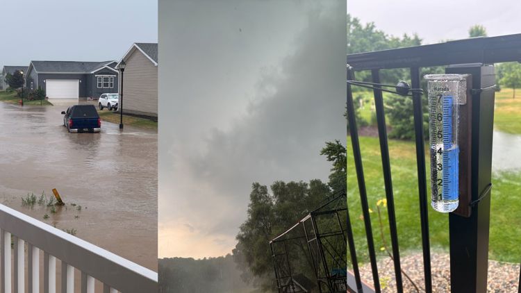
KENT COUNTY, Mich. — 13 ON YOUR SIDE meteorologists have been tracking severe weather in West Michigan Thursday afternoon. Severe thunderstorm warning and tornado warnings have been issued across West Michigan by the National Weather Service (NWS) since 2 p.m.
The first warning was for Southeastern Kent County and Western Ionia County and was set to expire at 3 p.m.
Just before 3 p.m. another severe thunderstorm warning was issued for Southeastern Ionia County, Northeastern Barry County, Southwestern Clinton County and Northwestern Eaton County. That warning lasts until 4 p.m. and also included a tornado watch. However, the tornado watch was cancelled around 3:40 p.m.
Shortly after 3 p.m. the NWS issued an additional severe thunderstorm warning for central Kent County until 3:45 p.m.
Around 3:45 a severe thunderstorm warning was issued for Northeastern Kent County and Northwestern Ionia County until 4:30 p.m. While there is no active tornado warning, residents in the area are advised to stay alert for a possible tornado.
At 4 p.m. a severe thunderstorm warning was issued for Eastern Newaygo County, Western Mecosta County and Northwestern Montcalm County lasting until 5 p.m. They also issued a tornado warning for Northeast Kent County and Northwest Ionia County.
That tornado warning was called off around 4:15 p.m. However, the NWS said the storm "remains strong," and that damaging wind gusts and hail are still possible.
Residents in the affected areas should be prepared for damage to roofs, siding and trees. If you are able, you should move to an interior room on the lowest floor of a building.
"Large hail and damaging winds and continuous cloud to ground lightning is occurring with this storm," said the NWS. "Move indoors immediately. Lightning is one of nature's leading killers. Remember, if you can hear thunder, you are close enough to be struck by lightning."
The NWS also advised that torrential rainfall is occurring with this storm which could lead to flash flooding. Remember not to drive your vehicle through flooded roadways.
►Make it easy to keep up to date with more stories like this. Download the 13 ON YOUR SIDE app now.
Have a news tip? Email news@13onyourside.com, visit our Facebook page or Twitter. Subscribe to our YouTube channel.
Watch 13 ON YOUR SIDE for free on Roku, Amazon Fire TV Stick, Apple TV and on your phone.