GRAND RAPIDS, Michigan — It's important to remain weather aware Tuesday with the possibility of severe thunderstorms for all of West Michigan.
TIMING & LOCATION
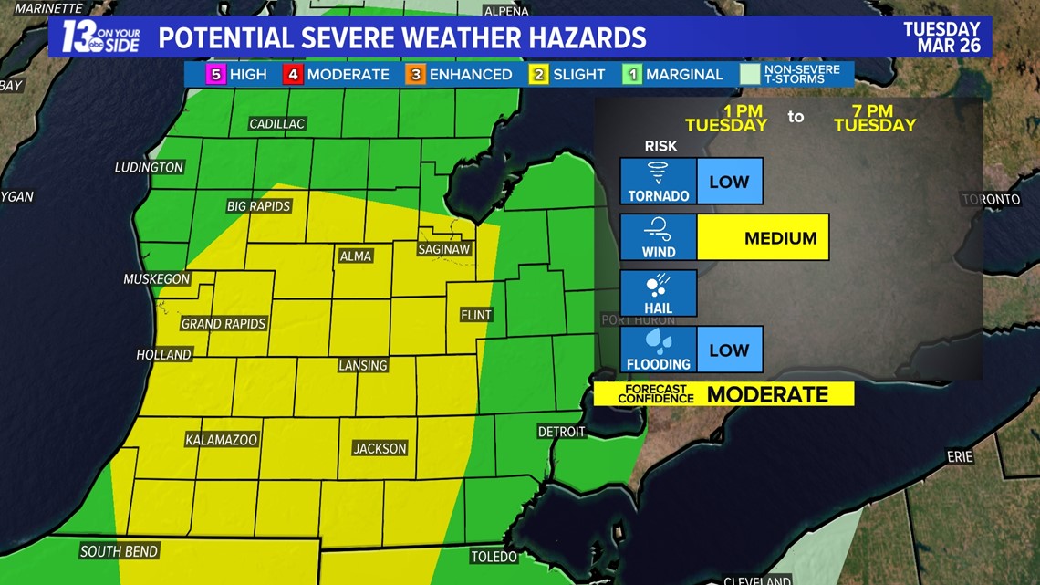
Thunderstorms are expected Tuesday afternoon to early evening—specifically from 1 p.m. to 7 p.m.—with the potential of any thunderstorm becoming strong to severe. The primary hazard is damaging wind gusts, but a brief spin-up tornado cannot be ruled out.
Much of West Michigan has been upgraded to a slight risk (2/5) from the Storm Prediction Center, meaning scattered severe storms are possible. The rest of West Michigan—north of the Muskegon to Fremont line—is under a marginal risk (1/5), meaning isolated severe storms are possible.


IMPACTS
Strong to severe level winds are the main concern with any thunderstorm development Tuesday afternoon. This is separate from the non-severe gustiness—30 to 40+ mph—that is expected throughout Tuesday.
There is also a low-end, but still existing chance, of a brief spin-up tornado with these storms. Hail is not expected, and a flash flooding risk remains low as thunderstorms will be quick-moving.
DISCUSSION
An incoming cold front will serve as the catalyst for thunderstorms to develop with plenty of wind shear for sustainability. It's a question of whether or not we muster enough instability to fuel storms into severe territory.
This will be dependent on the amount of clearing that occurs across West Michigan this morning into the midday hours. More clearing than expected will lead to more instability, while more rain and cloud coverage than expected will suppress thunderstorm potential.
The nature of the thunderstorms will be fast-moving, meaning the thunderstorm and severe risk will only be a few hours this afternoon into the early evening.
SAFETY
You should have multiple ways to stay weather aware and receive critical weather information.
There are five direct ways in which you can receive weather alerts.
1. NOAA Weather Radio
The first is NOAA Weather Radio. We often refer to them as the “smoke detector” for severe weather, because they will automatically sound an alarm in the case of a natural disaster or severe weather.
2. Local Broadcast
There is also always your local TV station. The 13 ON YOUR SIDE Weather Department streams on-air and online during an active storm.
3. Radio Station
Local radio stations should alert you if a storm is in your area. You can even set up devices like Alexa and Google Home to alert you with weather notifications.
4. Smartphone
Your smartphones also offer numerous ways to receive critical weather alerts. We have a 13 ON YOUR SIDE Weather App that will allow you to track the storm and receive alerts.
5. Outdoor Sirens
Outdoor sirens are also an option, as they will go off in the threat of immediate danger, but are only meant to be heard outdoors. So, if you are inside this should not be how you receive your severe weather alerts. Outdoor sirens can also be unreliable, difficult for those hard of hearing, and go off for other reasons beyond tornadoes.
SHARE PHOTOS and VIDEOS
If you would like to add to our reports text your photos along with your name and location to 616.559.1310.


►Make it easy to keep up to date with more stories like this. Download the 13 ON YOUR SIDE app now.
Have a news tip? Email news@13onyourside.com, visit our Facebook page or Twitter. Subscribe to our YouTube channel.
Watch 13 ON YOUR SIDE for free on Roku, Amazon Fire TV Stick, Apple TV and on your phone.

