MICHIGAN, USA — Impactful winter weather is nearly certain across West Michigan, with weather kicking off late in the day Thursday, peaking on Friday, and lingering throughout much of Christmas weekend.
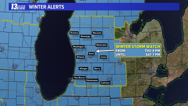
A Winter Storm Watch has been issued, with the combination of heavy snow, intense winds and falling temperatures increasing in likelihood.


Here’s a breakdown of the timing of this event:

Strengthening low pressure, potentially undergoing ‘bombogenesis,' will allow winter impacts to expand across the entire Great Lakes region from the end of Thursday into Friday. As this system pulls away to the north and east, there’ll be a transition to a lake effect snow event overnight Friday into Saturday. By the weekend, arctic air will be spilling into West Michigan.
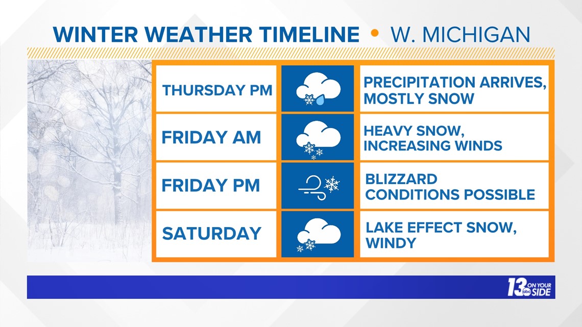
Precipitation will arrive by late afternoon on Thursday, with mostly snow expected. In previous forecasts, there were thoughts that precipitation could start off as a wintry mix and/or rain, but that no longer appears to be the case.
Regardless, snow will quickly intensify Thursday night into the early morning hours of Friday. As of now, accumulations of 4-8”+ are expected by daybreak Friday (8 a.m.). This will cause quick deterioration of roadways and overall travel.
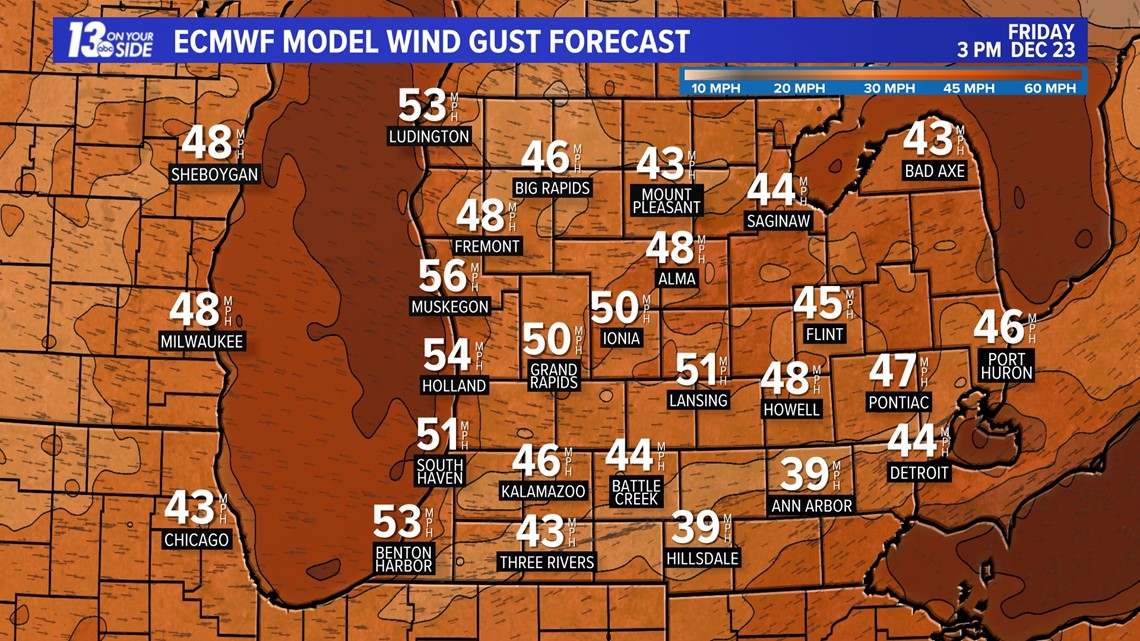
Friday will be the peak of the storm, with heavy snow and intense winds causing blizzard-like conditions. Several additional inches of snow, on the order of at least 6”+, will fall on Friday, leading to additional impacts. Gusts out of the west will likely approach 50+ MPH, even higher at the lakeshore. Travel will be greatly affected, and could get near impossible.
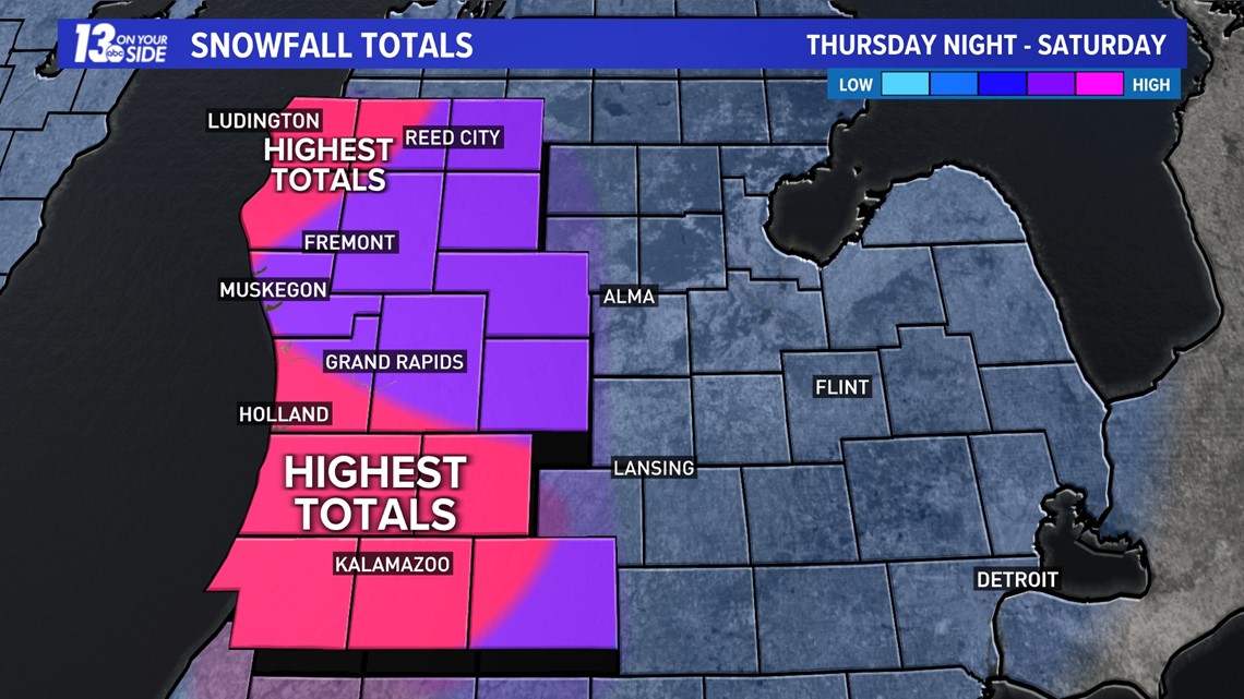
The system will begin to exit the region on Saturday, but that does not mean an end to the snowfall. Rounds of lake effect snow are expected Saturday afternoon. Northwest lake-effect snow usually results in heavy accumulation in Ottawa, Kalamazoo, Allegan, Van Buren, Mason and Lake County. While it's too early to determine how much more snow will accumulate, those areas should be prepared.


TERMS
As the storm arrives, you may hear local meteorologists use terms and/or verbiage that may be confusing.
BLIZZARD DEFINITION
Confidence is increasing that much, if not all, of West Michigan will contend with blizzard conditions Friday into early Saturday.
What does that mean? Here’s the definition of a blizzard from the National Weather Service:
- Sustained wind or frequent gusts to 35 MPH or greater
- Considerable falling and/or blowing snow, reducing visibility to under ¼ of a mile
- Conditions prevailing for a period of 3 hours of longer
There is a strong possibility these conditions could last 24 continuous hours around West Michigan, starting Friday and lasting through early Saturday.
BOMBOGENESIS DEFINITION
Bombogenesis—or a "bomb cyclone"—occurs when the pressure of a storm drops at least 24 millibars in 24 hours. A millibar is a measure of atmospheric pressure inside a storm, telling meteorologists how strong or weak the storm system is.
It usually happens when warm air rises ahead of an arctic air mass with a strong jet stream moving above it. The difference between the two air masses helps to strengthen the storm system, creating what's known as bombogenesis.
Bombogenesis usually occurs in strong Nor’easters that impact the East Coast in the winter but can happen anywhere where rapid pressure falls occur.
FINAL NOTES
We will be releasing more detailed snowfall totals tomorrow morning, but this is a broad view of what we are expecting. Consistency between model runs is increasing our confidence and making it more and more clear that impacts will be great.
►Make it easy to keep up to date with more stories like this. Download the 13 ON YOUR SIDE app now.
Have a news tip? Email news@13onyourside.com, visit our Facebook page or Twitter. Subscribe to our YouTube channel.